


Vancouver, British Columbia--(Newsfile Corp. - June 29, 2022) - Foremost Lithium Resource & Technology Ltd. (CSE: FAT) (OTCQB: FRRSF) (FSE:F0R0) (WKN: A3DCC8) (www.foremostlithium.com) ("Foremost Lithium", "Foremost" or the "Company") is pleased to announce that it has entered in to an agreement (the "Option Agreement") with Strider Resources Ltd. ("Strider") pursuant to which the Company has the right to acquire a 100% interest in the PEG NORTH CLAIMS located in the historic Snow Lake mining district in Manitoba (the "Peg North Claims"). The Peg North Claims consist of 28 claims hosting five known pegmatite dykes, [Cerny, et. al.1981] [1] and captures the northern extension of the Crowduck Bay Fault and surrounding area, known for its lithium-enriched pegmatite dyke clusters. The acquisition pursuant to the Option Agreement will significantly expand the Company's Snow Lake lithium holdings by 16,697 acres (6,757 hectares) to an amalgamated 43,031 acres (17,414 hectares) in the prospective Snow Lake pegmatite fields. The location of the newly acquired Peg North Claims is illustrated in Figure 1 below. In connection with this important acquisition, the Company wishes to take this opportunity to provide a comprehensive update and overview of the status of each of the properties comprising the Company's impressive package of lithium and precious metals assets.
John Gravelle, President & CEO of Foremost Lithium, states: "We now hold and/or have the right to acquire an aggregate of over 43,000 acres, (17,400+ hectares) of what Foremost considers to be tier-one lithium exploration properties in Snow Lake, Manitoba. This substantial increase in hectares will add to Foremost's previously disclosed inventory of 30 high-quality drill targets to explore and develop. The electrification movement is amongst us and the increased demand for lithium will be here for decades to come. This strategic option of the Peg North Claims continues to demonstrate Foremost's commitment to deliver long-term shareholder value."
Under the terms of the Option Agreement, Foremost has the right to acquire a 100% interest in the Peg North Claims, subject only to a 2% net smelter return royalty granted to Strider (the "NSR") (the "First Option") in consideration for making aggregate cash payments of $750,000, issuing Strider common shares having an aggregate value of $750,000, and incurring an aggregate of $3,000,000 in exploration expenditures on the Peg North Claims on or before the fifth anniversary of the effective date of the Option Agreement. The Common shares will be issued at a deemed price equal to the greater of (a) the average closing price of the Company's shares on the CSE for the last 30 trading days prior to the date such shares are issued; and (b) the minimum price permitted under the policies of the stock exchange.
In connection with signing the Option Agreement, the Company will make the initial option payment to Strider of $100,000 in cash and issue Strider an aggregate of 526,316 common shares at a price of $0.19 per share.
Once the First Option has been fully exercised, the Company may, at any time prior to commencement of commercial production on the Peg North Claims, exercise a second option to acquire one half (1/2) of the NSR (1%) for a cash payment of $1,500,000.
[1] P. Cerny, D.L. Trueman, D.V. Ziehlke, B.E. Goad, and B.J. Paul, "THE CAT LAKE-WINNIPEG RIVER AND THE WESKUSKO LAKE PEGMATITE FIELDS, MANITOBA." Manitoba Department of Energy and Mines, Mineral Resources Division Economic Geology Report ER80-1. 1981
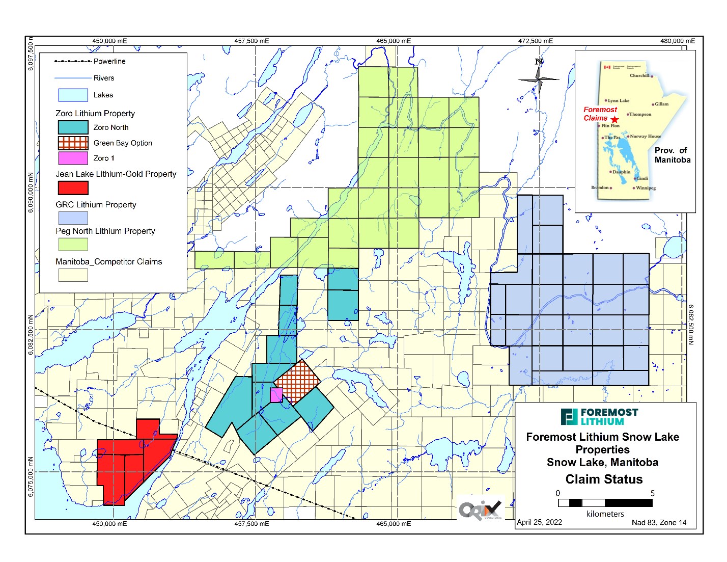
Figure 1 - Foremost Lithium Snow Lake District Claim Map showing the Jean Lake, Zoro, GRC and Peg North Claims assets. Foremost now controls an amalgamated 17,414 hectares (43,031 acres) in the highly prospective Snow Lake pegmatite fields, including the entire northern extension of the Crowduck Bay Fault
To view an enhanced version of this graphic, please visit:
https://orders.newsfilecorp.com/files/4689/129383_a5af844a94b7f9f3_001full.jpg
Foremost's initial exploration plans for these claims include a LiDAR survey (to discover never-before-seen outcrops for prospecting), an airborne high-definition magnetic survey, and follow up Mobile Metal Ions soil geochemistry ground proofing of high priority magnetic anomalies. This work will be carried out to define quality drill targets.
John Gravelle, President & CEO of Foremost Lithium, continues: "Foremost's acquisition of the Peg North Claims was a priority due to its excellent exploration potential based on the northeast extension of the Crowduck Bay and related faults that host the Thompson Brothers lithium mineralized pegmatite dykes. The mapped presence of lithium bearing pegmatites east and southeast of the Peg North Claims make this property prospective for lithium bearing pegmatite dykes." Mr. Gravelle further continues: "I'd like to personally express my most sincere gratitude to Dr. Mark Fedikow, Foremost's Vice President of Exploration, and Dan Ziehlke of Strider Resources for their work to complete this transaction."
Technical information contained in this press release, regarding the Peg North Claims, the Zoro Lithium Project, the Jean Lake Lithium and Gold Property, the Grass River Property and the Hidden Lake Lithium Property has been approved by the Company's VP of Exploration, Dr. Mark Fedikow, P.Eng., P. Geo, who is a "Qualified Person" within the meaning of National Instrument 43-101 Standards of Disclosure for Mineral Projects. Dr. Fedikow holds Honours B.Sc. and M.Sc. degrees in geology, geophysics and geochemistry from the University of Windsor, Canada, and a Ph.D. in exploration geochemistry from the School of Applied Geology, University of New South Wales in Sydney, Australia.
The technical content of this news release regarding The Winston Project has been approved by Dr. Michael Feinstein, CPG, who is a Qualified Person as defined by NI 43-101.
Cannot view this video? Visit:
https://www.youtube.com/watch?v=y_7ITu0YtW4
DESCRIPTION AND STATUS OF FOREMOST'S PROPERTIES
Zoro Lithium Project, Manitoba Canada
The Zoro Lithium Project is located at the east end of the 200 km long and 70 km wide Paleoproterozoic Flin Flon-Snow Lake Greenstone Belt approximately 20 km east of the historic mining town of Snow Lake (Figures 1 and 2). The project consists of 16 claims with a total of 3,603 hectares including the 100%-owned Zoro1 claim, that hosts the primary source of lithium on the property in Dyke 1, and the Green Bay and Manitoba option properties. Foremost holds the rights to 100% of the lithium resources on these properties. Nearby infrastructure includes a power line servicing the town of Snow Lake approximately 5 km south of the property, the Snow Lake airport, and an all-weather gravel road 11 km west of the property, as well as a rail link located at Wekusko Siding, 20 km to the south of Herb Lake Landing which is 30 km south of the property.
Geological Setting1
The Zoro Lithium Project is underlain by ocean floor volcanic rocks of the Roberts Lake allochthon and lesser amounts of Missi Group sedimentary rocks. The Ocean Floor rocks comprise mafic volcanic and related intrusions and the Missi Group consists of sandstone, siltstone, mudstone, and quartzo-feldspathic gneiss and migmatite. The Ocean Floor mafic volcanic rocks adjacent to the pegmatite dykes consist of a fine to medium-grained strongly foliated dark green lithology. These andesitic to basaltic lithologies are locally interbedded with volcaniclastic sedimentary rocks and all are intruded by a quartz-phyric granite intrusion (Figure 3).
Pegmatite dykes generally strike northwest to north-northwest with steep dips and crosscut the regional foliation at a low angle. The dykes tend to be concentric in internal structure and the grain size of the constituent minerals (potassium feldspar, quartz, spodumene and black tourmaline) coarsens towards the center of the dykes. This pattern may be locally interrupted by patches of saccharoidal albite, large muscovite aggregates and coarse albite stringers with garnet and beryl. Spodumene is concentrated in the cores of the dykes. Some of the dykes have been split into sub-parallel veins by post-emplacement tectonic activity.
Approach to Exploration
Integrated exploration on the project consists of soil and rock geochemical surveys, a drone magnetic survey, prospecting, and mapping all followed-up with diamond drilling. This has led to the discovery of 16 previously unknown spodumene-bearing pegmatite dykes and the delineation of multiple lithium targets. To date, 70 drill holes for 9,915 m have been completed on the property.
Source of Lithium
The principal source of lithium on the property is spodumene-bearing Dyke 1 with an inferred resource of 1,074,567 tonnes at 0.91% Li2O, 182 ppm Be, 198 ppm Cs, 51 ppm Ga, 1212 Rb, and 43 ppm Ta at a 0.3 percent Li2O cut-off .1 Please refer to the Company's NI 43-101 Technical Report titled "NI 43-101 Technical Report on the Zoro Lithium Project, Snow Lake, Manitoba" dated effective July 6, 2018, prepared by Dr. Mark Fedikow, P. Geo, and Scott Zelligan P. Geo. Tantalum mineralization has also been intersected in Dyke 1 with an assay of 0.113% Ta2O5 (cf. November 1, 2017 news release). Elsewhere on the property assays of 2.42% to 7.28% Li2O have been documented from spodumene-bearing pegmatite Dyke 5 on the property3 (cf. Green Bay Mining and Exploration Ltd. Corporation File).
Metallurgy
Preliminary metallurgical testing by SGS Canada Inc. of a spodumene concentrate from Dyke 1 indicates that a high-grade (6% Li2O) lithium concentrate can be produced from Dyke 1 mineralization using industry standard methods.2
Recent Exploration
Lithium
In 2022, a ten-hole 1,509-meter drill program was undertaken to test Mobile Metal Ion ("MMI") soil geochemical anomalies and assess the deeper levels of high-grade spodumene pegmatite Dyke 8 discovered in 2018.
The sixteenth spodumene-bearing pegmatite dyke on the Zoro property was discovered during this program. It was intersected by two drill holes (c.f. April 26, 2022, news release). DDH FM22-70 drilled at -50 degrees inclination intersected two pegmatite intercepts totaling 4.9 meters with up to 15% light green spodumene crystal aggregates. A second hole, DDHFM22-70B was drilled at a steeper inclination of -65 degrees to undercut the first pegmatite intersection. This hole intersected a five-meter intercept of the same spodumene mineralized pegmatite as hole FM22-70. The host rock to these pegmatites is a fine-grained foliated basalt. The location of Dyke 16 in relation to all other pegmatite dykes intersected on the Zoro property is illustrated in Figure 4.
Dyke 8
High-grade spodumene pegmatite Dyke 8 was discovered on the Zoro property in 2018 by the drill testing of a Mobile Metal Ions soil geochemical anomaly. Drill hole Far18-35 testing the MMI anomaly intersected 36.5 m of spodumene-bearing pegmatite. Assay results from hole FAR18-35 included three separate intercepts of high-grade lithium including 12.3 m of 1.1% Li2O, 4.4 m of 1.2% Li2O, and 2.2 m of 1.5% Li2O (cf. April 26, 2022, news release).
In 2022, DDHFM22-71 was drilled at -65 degrees to undercut the 2018 pegmatite intersections. A 4.5-meter spodumene-bearing pegmatite was intersected between 70.45 and 75.89 meters before being truncated by a fault. This intercept is 37 meters below the previous 2018 drill intercepted Dyke 8 spodumene mineralization. A further pegmatite was intersected below the fault between 84.4 and 86.65 meters.
To date, Dyke 8 has drill indicated dimensions of 120 m in length, 5-15 m in width and has been drilled to a depth of 157 m (cf. April 26, 2022, news release).
Gold
Numerous intersections of core intersected mineralized zones characterized by disseminated and veinlet arsenopyrite with lesser chalcopyrite, sphalerite, and pyrite. Mineralized sections were intersected in silicified and variably altered dacite and basalt volcanic rocks with or without quartz veins.
Assay Samples
A total of 19 core samples of pegmatite have been collected from drill core. Fourteen samples were collected from pegmatite with visible spodumene, and five samples were collected from pegmatite without visible spodumene. Nine samples were collected from lithologies other than pegmatite. Fifty-seven samples were collected from core mineralized with disseminated and stringer arsenopyrite and lesser pyrite, chalcopyrite, and sphalerite for gold assay.
After logging and photographic recording, all core samples were sawn in half and one half of the core has been shipped to Activation Laboratories (Ancaster, Ontario). Remaining drill core is stored in a secure facility in Snow Lake.
Pegmatite samples will be analysed using UT-7 lithium and related element analysis after total dissolution by sodium pyrophosphate with finish by ICP-MS. Samples for gold assay were undertaken on 30-gram samples with fire assay and finish by Instrumental Neutron Activation.
Results for all samples are pending but will be reported in a news release and on the website once available.
Future Exploration
Exploration on the property is ongoing with prospecting, mapping and geochemical surveys following up on a recently completed (June 2022) drone magnetic survey. The drone survey was completed by EarthEx Geophysical Solutions Inc. Interpreted results from the drone magnetic survey will provide the focus for ongoing exploration. A drone-assisted LiDAR survey is planned for the summer of 2022.
1: Fedikow, M.A.F. and Zelligan, S. 2018. NI 43-101 Technical report on the Zoro Lithium Project, Snow Lake, Manitoba; 188p.
2: Grammatikopoulos, T., Aghamirian, M., Fedikow, M.A.F. and Mayo, T. 2020 : Mineralogical characterization and preliminary beneficiation of the Zoro Lithium Project, Manitoba, Canada: HTTPS://DOI.ORG/10.1007/S42461-020-00299-2.
3: Green Bay Mining and Exploration Ltd. Corporation File: 1956: Manitoba Mining Recorder, Corporate and Assessment Files.
Figure 1. Location map for the Zoro Lithium Project.
To view an enhanced version of this graphic, please visit:
https://orders.newsfilecorp.com/files/4689/129383_a5af844a94b7f9f3_002full.jpg

Figure 2: Regional geology map of the Flin Flon-Snow Lake Greenstone Belt and the location of the Zoro Lithium Project.
To view an enhanced version of this graphic, please visit:
https://orders.newsfilecorp.com/files/4689/129383_a5af844a94b7f9f3_003full.jpg

Figure 3. Geological setting of the Zoro Lithium Project with claim boundaries.
To view an enhanced version of this graphic, please visit:
https://orders.newsfilecorp.com/files/4689/129383_a5af844a94b7f9f3_004full.jpg
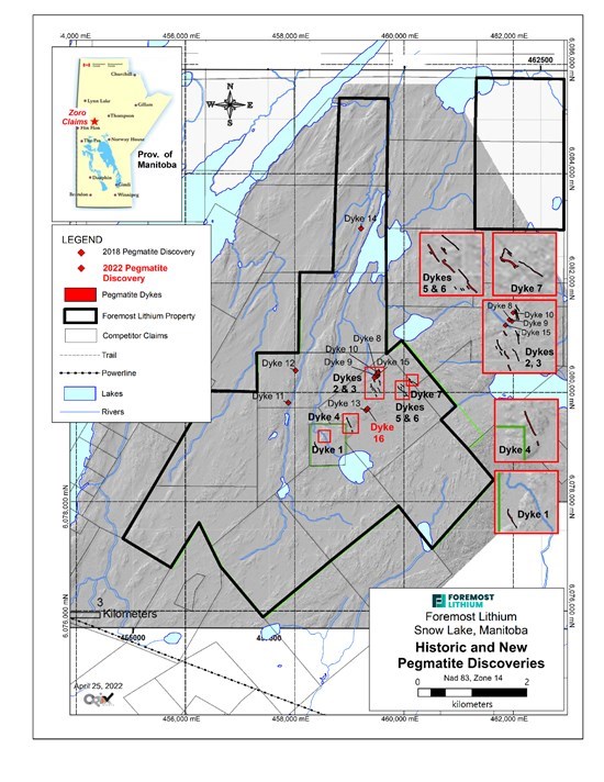
Figure 4. Location of Dyke 16 in relation to previously discovered pegmatite dykes on the Zoro Lithium Project.
To view an enhanced version of this graphic, please visit:
https://orders.newsfilecorp.com/files/4689/129383_a5af844a94b7f9f3_005full.jpg
Jean Lake Lithium and Gold Property, Manitoba Canada
The five claim, 1002-hectare Jean Lake Lithium and Gold Property is situated in west-central Manitoba, 15 kilometers east of the historic town of Snow Lake. It is hosted by the Early Proterozoic (1.832 Ga) Rex Lake Plutonic Complex which is a circular intrusion 8 km in diameter. The property hosts the historic west-northwest striking Beryl lithium pegmatites rediscovered in August of 2021 in blasted trenches beneath 80 years of organic deadfall and glacial sediment. The 270-degree trending dykes are characterized by coarse grained light green spodumene crystals in a matrix of potassium feldspar, quartz, and muscovite. The host rocks are coarsely porphyritic gabbro. The property also hosts the shear zone-hosted Sparky Gold Occurrence discovered in 1918. The gold mineralization is associated with disseminated and near-solid fracture fillings consisting of fine-grained to blocky arsenopyrite with lesser pyrite and chalcopyrite hosted within sheared and silicified massive basalt and gabbro.
The location of the Beryl Pegmatites ("B1" and "B2") is illustrated on a Jean Lake claim map in Figure 1. B3 is a pegmatite without visible spodumene.
Recent Exploration
Lithium
Five representative rock chip samples of spodumene-bearing mineralization were collected in August, 2021 from blast material in two trenched locations of the Beryl Pegmatites. Two of the samples were apple green, coarse grained spodumene (Far21-1 and -2)) and three samples were from straw-coloured, finer grained spodumene (Far21-3,4 and 5)).
Samples were shipped to Activation Laboratories in Ancaster (Ontario) for analysis, applying the UT-7 method which uses a total dissolution of the sample by sodium peroxide fusion and ICP-MS finish. This analytical approach is the standard analytical technique employed by the Company on its Zoro and Jean Lake lithium projects for the analysis of pegmatite.
Results indicate all samples returned high-grade lithium contents regardless of the textural characteristics of the spodumene (Table 1).
Table 1. Lithium analyses for two styles of spodumene mineralization at the Beryl Pegmatite,
Jean Lake Property, Snow Lake area, Manitoba.
| Element | Li20% | Li2C03% |
| Beryl Pegmatite B1: | ||
| FAR 21L-1 | 3.89 | 9.63 |
| FAR 21L-2 | 5.17 | 12.78 |
| Beryl Pegmatite B2: | ||
| FAR 21L-3 | 4.74 | 11.71 |
| FAR 21L-4 | 4.09 | 10.11 |
| FAR 21L-5 | 3.81 | 9.42 |
Gold
Fifteen representative rock chip samples from the Sparky Occurrence returned assay results with maximum contents of 20.9 g/t gold (Table 2). All but one sample exceeded 1 g/t gold. Grab samples representative of mineralization exposed in outcrop and in pits were collected from pervasively silicified wall rock containing brecciated and mineralized quartz veins. The deformation observed in the rocks sampled is attributed to faults cutting the eastern portion of the Rex Lake Pluton which is bounded on the east by the crustal scale Crowduck Bay Fault.
Gold assays are determined by fire assay using a 30-gram sample followed by an instrumental neutron activation finish.
Table 2. Summary of gold assay results, Jean Lake Property.
| Sample | UTM East | UTM North | Grams Per Ton/ Gold | G/T Gold |
| Datum: NAD83 Zone 14 | ||||
| FAR21G-1 | 451647 | 6076201 | 1.6 | 1.66 |
| FAR21G-2 | 451647 | 6076201 | 138 ppb | 0.138 |
| FAR 21G-3 | 452451 | 6076406 | 20.9 | 20.9 |
| FAR 21G-4 | 452451 | 6076406 | 8.6 | 8.66 |
| FAR 21G-5a | 452409 | 6076351 | 1.9 | 1.93 |
| FAR 21G-5b | 452409 | 6076351 | 1.8 | 1.84 |
| FAR 21G-6a | 452377 | 6076246 | 11.2 | 11.2 |
| FAR 21G-6b | 452377 | 6076246 | 6.4 | 6.42 |
| FAR 21G-7 | 452356 | 6076171 | 2.0 | 2 |
| FAR 21G-8a | 452417 | 6076377 | 7.6 | 7.63 |
| FAR 21G-8b | 452417 | 6076377 | 8.6 | 8.66 |
| FAR 21G-9 | 452366 | 6076105 | 4.0 | 4.05 |
| FAR 21G-10 | 452395 | 6076407 | 1.3 | 1.38 |
| FAR 21G-11 | 452356 | 6076171 | 1.0 | 1 |
| FAR 21G-12 | 452441 | 6076396 | 1.2 | 1.29 |
Laboratory contamination was not detected in the analysis of the samples based on the replicate analyses of the method blank. The analysis of both internal standards and International Reference Materials indicates the analyses are accurate and reproducible.
Ongoing exploration consisting of prospecting and geochemical surveys is planned to commence in June, 2022 utilizing the results from recently completed (April, 2022) drone-assisted magnetic surveys. The drone surveys were completed by EarthEx Geophysical Solutions Inc. Drone-assisted LiDAR surveys are planned for the summer of 2022.

Figure 1. Location of the Beryl Pegmatites (B1 and B2). B3 is a barren, non-spodumene-bearing pegmatite that is on trend (270o) with B1 and B2.
To view an enhanced version of this graphic, please visit:
https://orders.newsfilecorp.com/files/4689/129383_a5af844a94b7f9f3_006full.jpg
Grass River Claims Property (GRC) Manitoba, Canada
The recently acquired Grass River Claims Property consists of 27 claims totaling 14,873 acres located 30 km east of the historic town of Snow Lake and 6.5 kilometers east of the Company's Zoro Lithium Project. The GRC hosts multiple pegmatites exposed in outcrop and 7 drill-indicated spodumene-bearing pegmatite dykes.
The bulk of mineral exploration in the Snow Lake area was undertaken in the late 1950's and was primarily designed to assess the general area for base metal massive sulphide mineralization. Ground geophysical surveys (electromagnetics and magnetics) were the primary tool coupled with boots on the ground prospecting. Many holes were drilled to assess base metal environments. During the drilling of geophysical targets, several spodumene pegmatites were intersected1.
A total of 10 pegmatites are exposed in surface outcrop on the property and together with the 7 drill-indicated spodumene-bearing dykes (Figure 1) will be part of the exploration focus in 2022. Ongoing data interpretation of results from a drone-assisted magnetic survey completed by EarthEx Geophysical Solutions Inc. in June of 2022 will guide follow-up prospecting and geochemical surveys expected to commence in July of 2022. These surveys will be supplemented with a drone-assisted LiDAR survey planned for July 2022. A drill program is planned for later in the year
Results of the magnetic and LIDAR surveys will be released in a news release and on the Company's website when complete.
1: Cancelled Assessment File 90611, Manitoba Mining Recorder, Manitoba Natural Resources and Northern Development.
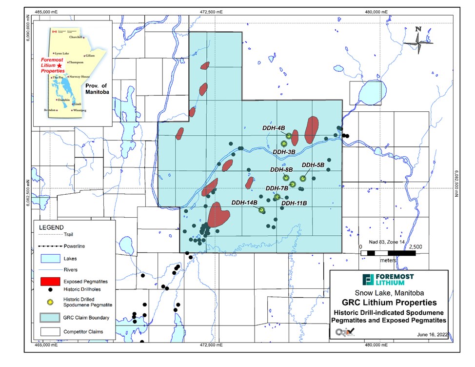
Figure 1. Compilation of pegmatites exposed in surface outcrop1 and drill intersected spodumene-bearing pegmatite2 on the Grass River Lithium Property, Snow Lake area, Manitoba.
To view an enhanced version of this graphic, please visit:
https://orders.newsfilecorp.com/files/4689/129383_a5af844a94b7f9f3_007full.jpg
Data Sources
1: Bailes, A.H. 1985: Geology of the Saw Lake area, Geological Report GR83-2, 47 pages and Map GR83-2-1.
2: Cancelled Assessment File 90611, Manitoba Mining Recorder, Manitoba Natural Resources and Northern Development.
The Hidden Lake Lithium Property Northwest Territories, Canada
The Hidden Lake Lithium Property is located 45 km east of Yellowknife, NWT (Figure 1) and consists of 5 contiguous claims, totaling 1,659.29 hectares (Figure 2). The property is just north of Highway 4 (Ingraham Trail) providing excellent access. The exploration target on the property is lithium-bearing spodumene pegmatite dykes which are visible from aerial imagery as elongated white linear features visible through vegetation and soil due to their high reflectance.
Geological Setting
The Hidden Lake Property lies within the southern Archean Slave Craton of the Canadian Shield which is comprised of Mesoarchean gneissic basement covered by the Neoarchean Yellowknife Supergroup supracrustal assemblage. The Yellowknife Supergroup consists of a thick sequence of metavolcanic rock and metasedimentary rock which is dominated by a regionally homogenous sequence of interbedded greywacke-mudstone turbidites of the multiply deformed Burwash Formation east of Yellowknife (Figure 3). This region was subsequently intruded by the Prosperous suite of S-type biotite muscovite leucogranite plutons which are spatially associated with granitic pegmatites.
Granitic Pegmatites
These pegmatites intrude both the surrounding Burwash Formation and the granitic plutons and form the Yellowknife Pegmatite Field. Depending on their proximity to the granite intrusion, the pegmatite complexes commonly show regional zoning in their mineralization and can be rare element bearing. Lithium enrichment occurs in an outer zone typically 2 to 3 kms from the intrusion accompanied by Be, Ta, Nb and Ca enrichment (Sinclair, 1996).
The lithium bearing pegmatites that are targeted for exploration are white to light grey, coarse to very coarse-grained, and comprised of K-feldspar (microcline), plagioclase (albite), quartz, muscovite and spodumene with trace amounts of apatite, biotite, tourmaline, columbite and montebrasite. The dykes consist of long, discontinuous bodies oriented in an NNE-SSW direction (between 010° and 020°) and range from 3 to 11 m wide and 300 to 800 m long. The bodies are zoned and spodumene content typically ranges from 10% to 20% by volume, with up to 35% locally within the center of the bodies. Spodumene crystals were green to light greenish grey, up to 60 cm long and were typically oriented parallel to the dyke boundaries along the edges and perpendicular to the boundaries in the center of the dykes (Sinclair, 1996).
Historic Work
Initial prospecting of the Yellowknife district originated when rare-element pegmatites were first discovered in the 1930's, followed by the discovery of lithium-bearing pegmatites in the 1950's. The most significant historic exploration carried out on the property has been undertaken on the D12 pegmatite that was first discovered by the Geological Survey of Canada in1947. It is described as a 1,000 ft. long and 30 ft. wide, spodumene-bearing pegmatite dyke. It has since been subjected to trenching and detailed mapping1. In 1978, Canadian Superior Exploration Ltd. mapped and sampled several spodumene-bearing dykes on and surrounding the current Property, the largest of which was D122. Chip samples collected from the historic trenches at D12 yielded 1.37% to 3.01% Li2O (NWT Geoscience Detailed Showing Report ID 085INW0042).
2016 Exploration
Dahrouge Geological Consulting Ltd. (Dahrouge) undertook exploration work in 2016 and 2017 on behalf of 92 Resources Corporation3. This work consisted of prospecting, grab sampling, detailed mapping, and channel sampling. Only the results of the 2016 program are relevant to the Hidden Lake Property.
Prospecting in May of 2016 included outcrop examination and the collection of 5 grab samples from the D12 dyke. The samples were sealed in labelled bags and shipped to Activation Labs Ltd. (ActLabs), in Kamloops, B.C., where they were analyzed using the sodium peroxide fusion ICP-OES + ICP-MS Ultratrace 7 package (UT-7). Those samples with a Li value above the detection limit of 10,000 ppm underwent the sodium peroxide fusion ICP-OES lithium ore analysis package (Code 8 Li Ore).
Subsequently a channel sampling program was completed between August 16th and September 7th, 2016. A total of 308 channel samples were collected from 61 channels cut across dykes D12, HL1, HL3 and HL4 Table 1.
Table 1: 2016 channel sampling details.
| Pegmatite | Length (m) | Number | Number |
| of Channels | of Samples | ||
| D12 | 350 | 15 | 85 |
| HL1 | 690 | 16 | 65 |
| HL3 | 800 | 15 | 89 |
| HL4 | 400 | 15 | 69 |
Results
In 2016 a total of 5 grab samples and 308 channel samples were collected during the two Hidden Lake field programs carried out in 2016. Five grab samples from dyke D12 assayed 1.63 - 3.06% Li2O. Channel sample results were presented as weighted averages for individual channels for each dyke. The thickest section of D12 was 11.58 m wide and returned a weighted average of 1.53% Li2O and included a 9.02 m section of 1.90% Li2O. A channel from the HL1 dyke assayed 1.26% Li2O over 8.72 m and an 8.78 m channel from the HL3 dyke assayed 1.58% Li2O. A 5.78 m channel from HL4 assayed the highest Li2O of 1.71% over 5.78 m. Significant grades of tantalum were recorded with an average of 54 pm Ta2O5 for the four dykes. The maximum value was 402 ppm.
2018 Exploration
Dahrouge also undertook an exploration program in 2018 on behalf of Foremost Resources4. The purpose of the drilling was to test the vertical continuity of spodumene mineralization in the subsurface. This work took place between May 22nd and June 10th, 2018 and consisted of 1079.37 m of core drilled in ten drill holes on pegmatite dykes HL-001 through HL-003 and D-12 (Figure 4). A total of 197 core samples were collected and submitted for assay at SGS Mineral Services Lakefield facility. Intersected pegmatites were typically composed of quartz, plagioclase, feldspar, muscovite, spodumene and accessory minerals consisting of tourmaline and epidote.
Drill hole specific information including core samples collected for assay is provided in Table 2.
Table 2: Pegmatite intersection and sample collection summary.
| Hole ID | Target | Easting | Northing | Overburden Depth (m) | EOH Depth (m) | Pegmatite Intersection Sum (m) | Number of Samples |
| HL18-001 | D-12 | 374935 | 6936971 | 0.00 | 109.00 | 15.10 | 34 |
| HL18-002 | D-12 | 375023 | 6937090 | 4.23 | 101.34 | 10.98 | 26 |
| HL18-003 | D-12 | 374893 | 6936899 | 5.16 | 108.94 | 11.12 | 19 |
| HL18-004 | HL-1 | 373748 | 6936978 | 5.25 | 106.19 | 7.95 | 19 |
| HL18-005 | HL-1 | 373361 | 6937389 | 6.45 | 108.82 | 3.79 | 16 |
| HL18-006 | HL-4 | 373440 | 6937524 | 0.30 | 108.94 | 7.72 | 16 |
| HL18-007 | HL-4 | 373407 | 6937465 | 0.10 | 109.00 | 5.98 | 13 |
| HL18-008 | HL-4 | 373361 | 6937389 | 0.00 | 108.94 | 5.62 | 12 |
| HL18-009 | HL-3 | 373364 | 6937097 | 0.70 | 109.20 | 8.68 | 20 |
| HL18-010 | HL-3 | 373306 | 6937011 | 1.05 | 109.00 | 8.97 | 22 |
| Total: | 10793.37 m | 171.82 m | 197 |
Results
Pegmatites intersected in this drill program were marked by fine to very coarse grained spodumene crystals varying from 7-10 modal percent in dyke HL3 to 15-25% modal percent spodumene crystals in dyke D12.
All spodumene-bearing dykes tested during the 2018 drill program intersected high-grade 1.0-2.0% Li2O over individual widths that varied from 2.0 to 9.2 m or total widths of between 3.79 m and 15.10 m (Table 3; cf. September 10, 2018, news release). The assay results for 2018 drill core confirm the presence of high grade spodumene-bearing pegmatite dykes on the property and reflect the historic assay results from 2016 surface channel samples.
Table 3. Summary of assay results, 2018 Hidden Lake drill program.
| BHID | Li2O (%) | Ta (ppm) | Cs (ppm) | Nb (ppm) | Length (m) |
| Dyke D-12: HL18-001 | 1.5 | 33.4 | 40.6 | 48.7 | 9.0 |
| Dyke D-12: HL18-002 | 1.7 | 34.0 | 33.2 | 45.3 | 5.0 |
| Dyke D-12: HL18-003 | 1.6 | 32.4 | 47.2 | 44.4 | 9.2 |
| Dyke HL-1: HL18-004 | 1.6 | 24.4 | 29.0 | 29.0 | 7.0 |
| Dyke HL-1: HL18-005 | 1.2 | 41.8 | 33.1 | 45.8 | 2.0 |
| Dyke HL-3: HL18-006 | 1.4 | 21.5 | 46.2 | 25.6 | 7.0 |
| Dyke HL-3: HL18-007 | 2.0 | 43.6 | 32.9 | 52.8 | 5.2 |
| Dyke HL-3: HL18-008 | 1.3 | 42.5 | 40.9 | 54.6 | 3.8 |
| Dyke HL-2: HL18-009 | 1.5 | 7.8 | 28.6 | 12.0 | 2.0 |
| Dyke HL-2: HL18-010 | 1.0 | 15.1 | 31.4 | 17.2 | 7.0 |
Assay
Pegmatite intersections in the drill core were sawn in half with one half of the sample collected for assay. The samples were shipped to Activation Laboratories (Ancaster, Ontario) digested with a sodium peroxide fusion followed by ICP-OES/MS analysis. Assay results are summarized in Table 3.
Future Exploration
Future exploration is planned to expand the lithium resource at Hidden Lake with additional diamond drilling based on an integrated exploration plan using state-of-the-art drone assisted geophysical surveys and rock and soil geochemical techniques.
1: Mulligan, R. 1975. Geology of Canadian Lithium Deposits. Geological Survey of Canada, Economic Geology Report No. 21
2: Morrison, M. 1978. Report on a trenching programme and geological survey of the LU3, 5, 8, 9 and 10 mineral claims, Yellowknife area. NWT assessment report 080847.
3: Goreham, J. 2018: 2016 and 2017 geological and geochemical exploration on the Hidden Lake property, Yellowknife, N.W.T. report for property owner 92 Resources Corp., 29p.
4: Wood, A. 2018: Summary memo for the 2018 Hidden Lake P1 drill program, Yellowknife area, N.W.T., 12p.
Sinclair, W.D., 1996. Granitic Pegmatites; in Geology of Canadian Mineral Deposit Types, (ed.) O.R. Eckstrand, W.D. Sinclair and R.I Thorpe. Geological Survey of Canada, Geology of Canada. No. 8 p. 503-512.

Figure 1. Location of the Hidden Lake Lithium Property, Yellowknife area, N.W.T.
To view an enhanced version of this graphic, please visit:
https://orders.newsfilecorp.com/files/4689/129383_a5af844a94b7f9f3_008full.jpg

Figure 2. Current claim map, Hidden Lake Property, N.W.T.
To view an enhanced version of this graphic, please visit:
https://orders.newsfilecorp.com/files/4689/129383_a5af844a94b7f9f3_009full.jpg

Figure 3. Geological setting of the Hidden Lake Lithium Property.
To view an enhanced version of this graphic, please visit:
https://orders.newsfilecorp.com/files/4689/129383_a5af844a94b7f9f3_011full.jpg

Figure 4. Summary of drill hole locations and targets, Hidden Lake Lithium Property, N.W.T.
To view an enhanced version of this graphic, please visit:
https://orders.newsfilecorp.com/files/4689/129383_a5af844a94b7f9f3_012full.jpg
WINSTON PROPERTY NEW MEXICO, UNITED STATES
Dr. Michael Feinstein, CPG, QP, has visited the Winston Project area on ten separate occasions since October 2020. He conducted confirmatory sampling of the known historic mines, as well sampling the prominent structural trends along strike.
All samples were collected under the direct supervision of Dr. Michael Feinstein, and securely transported to the Tucson facility of ALS Laboratories for analysis. Ore characterization samples from these three mines returned peak values of: 66.5 g/t gold with 2,940 g/t silver from Little Granite, 26.8 g/t gold and 940 g/t silver from Ivanhoe, and 44.9 g/t gold and 517 g/t silver from Emporia.
This sampling confirmed the occurrence of high-grade material at all three of the historic mines, but also in several locations away from these areas. Foremost expanded its footprint, increasing the property from 415 acres to 2,980 acres, and increased its mineral rights from 14 to 150 BLM Lode Mining Claims. Previously, no modern exploration efforts have systemically assessed the northern portion of the Chloride District.
| Winston Project | ||
| *Highest Grade Sample From Each Mine | ||
| Mine | Au_ppm | Ag_ppm |
| Little Granite | 66.5 | 2,940 |
| Ivanhoe | 26.8 | 940 |
| Emporio | 44.9 | 517 |
| Prospecting Best | 41.5 | 4,610 |
Project Highlights
The project has contiguous landholdings totaling approximately 150 claims covering almost 3,000 acres. Claims are targeted along footprint of mineralization extending for more than 8 km of strike.
Historic drilling in early 1980s suggests potential for high-grade ore shoots within larger mineralized envelopes. The Chloride District saw a rush of miners and prospectors in the 1860s-1890s, a period of renewed mining activity in the 1980s, and has been largely unexplored by modern methods.
Potential for District-Scale discovery in a Precious Metal Endowed Low-Sulphidation Epithermal Vein System.
Ground geological mapping and surveying has utilized high resolution satellite imagery and LiDAR (laser-generated infrared light beams) to construct a detailed digital model of the area. This 3D GIS will be used for all drill targeting and project planning. Special attention will be given to maintaining a high level of vertical accuracy due to the local topography.
Exceptional results from property-wide confirmatory sampling completed in 2021 include:
-Measured width Highlights:
3.35 g/t Au with 245 g/t Ag from a 0.3m channel sample inside the Little Granite Decline.
1.97 g/t Au with 232 g/t Ag from a 0.3m channel sample across JAP vein at LG mine.
29.2 g/t Au with 462 g/t Ag from a 0.6m continuous chip sample in north zone.
3.2 g/t Au with 34 g/t Ag from a 1.0m continuous chip sample in north zone.
0.75 g/t Au with 489 g/t Ag from a 0.3m continuous chip sample in north zone.
-Prospecting Highlights:
Sample 1671079 collected at a prospect pit in recently staked ground returned 41.5 g/t Au with 4,610.0 g/t Ag.
Samples 1671021, 1671024, 1671027 were collected from the same vein trend over 300m of strike
#1671021 returned 20.6 g/t Au with 21.0 g/t Ag.
#1671024 returned 12.3 g/t Au with 381.0 g/t Ag.
#1671027 returned 5.7 g/t Au with 254.0 g/t Ag.
For the 155 samples across the project, gold values range from Below Detection (BD; <0.02 for Au) to a maximum of 66.5ppm, and Silver values range from BD (<0.02 for Ag) to a maximum of 4,610ppm.
Geological Setting of the Winston Project
The Winston Project, situated in the historic Black Range Mining District of southwestern New Mexico, covers 36 square kilometers of the northern portion of the Chloride District. High-grade deposits of silver and gold were discovered in 1880 and the area was a major producer until the 1893 silver price crash. Little production or modern exploration has occurred since.
The mineralization is of the well-documented Low-Sulphidation Epithermal type. Deposits of this style are emplaced throughout the Cordillera of North and South America and elsewhere in similar tectonic settings. This style of mineralization is known world-wide and hosts some of the highest-grade gold/silver mines, such as: Hishikari in Japan, Fruta del Norte in Ecuador and Round Mountain in Nevada.
On the Winston Property, the primary structure is the Paymaster Fault which is readily traced both on the ground and by satellite imagery. Locally, the mineralized veins are generally associated with north-south trending structures. The overall controlling geological feature is known as the Rio Grande Rift, which extends into northern Mexico hosting several past and present silver mines.
Foremost's Winston Project enjoys a close association with volcanic host rocks which formed at a similar time as the mineralization. Individual mines and prospects generally show strong controlling geological structures, typically north-south high angle faulting associated with the Rio Grande Rift (RGR). The RGR is a crustal-scale feature which extends over 1,200 kilometers, from northern Mexico to central Colorado.
Precious metal deposits of note along the RGR include the historic Creede Mining District in southwestern Colorado. The timing of mineralization is within several million years of that on the Winston Project, where alteration minerals have been dated at approximately 26.5 Ma. The Creede District has recorded production of over 84 million ounces of silver. Hecla Mining Corp., a premier US silver producer, is undertaking a major effort in the Creede District to bring a new mining complex online.
Located 100km to the east, The Mogollon District in western New Mexico has produced more than 13 million ounces silver and 270k ounces old. Mineralization is of the same Low-Sulphidation Epithermal Vein Type. Summa Silver is currently exploring the Mogollon Camp.
Little Granite Mine
The Little Granite Mine is a past-producing high-grade silver-gold mine hosted in Tertiary volcanics. The main vein has been traced for over 200 meters by past drilling and underground workings and remains open along strike to both the north and south, and at depth. Historically reported high-grade values were confirmed in limited re-sampling by Foremost in late 2020. Historic drill reports suggest the primary vein widens to more than 4m (12ft) true width, at depth.
Ivanhoe - Emporia Mines
The Ivanhoe - Emporia is a past producing gold-silver mine. Its main shaft was sunk to 384 feet depth with a 370 ft. decline and multiple working levels. There is potential for large tonnage of lower grade, stockwork veins surrounding high grade veins mined in the past. The strike continuation needs to be explored as favorable structural conditions persist along the bends and jobs of the Paymaster Fault.
Conclusion
Foremost is committed to commence a drill program in 2022 on multiple targets on the property. Past preparatory work for drilling has included data compilation both of historic and recent work, along with acquisition of high-resolution LiDAR data to allow construction of an accurate terrane model. This property had little to no modern exploration since the early 1980s and with such high-grade samples returned, the Company is keen to see the full potential from the Winston Gold/Silver Project.
There has been insufficient exploration to define a mineral resource. The potential quantities and associated grades have not been defined by drilling, but historic production in the district reflects the potential scope of orebodies which may be encountered. It is uncertain if further exploration will result in the delineation of a mineral resource.
QA/QC Statement-
166 samples have been processed by ALS Laboratories' ("ALS") for Precious Metals and Multi-Elements. All Foremost's (previously FAR Resources) rock sample assay results have been independently monitored through a quality assurance/quality control ("QA/QC") protocol which includes the insertion of blind standard reference materials at regular intervals. Samples were maintained by Dr. Feinstein and securely transported to ALS sample preparation facilities in Tucson, Arizona and Reno, Nevada. Sample pulps were sent to ALS's labs in Vancouver, Canada, for analysis.
All samples were of hard rock and prepared by fine crushing to 70% passing <2mm, riffle split, and then pulverization to 80% passing < 75 um (ALS Method Prep-31). Gold content was determined by fire assay of a 50-gram charge with ICP finish (ALS method Au-GRA22). Silver and 47 other elements were analyzed by ICP methods with four-acid digestion (ALS method ME-MS61). Over-limit samples for Ag, and Cu were determined by ore-grade analyses Ag-OG62, Cu-OG62, respectively.
ALS Laboratories is independent of Foremost and its Vancouver facility is ISO-17025 accredited. ALS also performed its own internal QA/QC procedures to assure the accuracy and integrity of results. Parameters for ALS' internal and Foremost's external blind quality control samples were acceptable for the samples analyzed. Foremost is not aware of any sampling, or other factors that could materially affect the accuracy or reliability of the data referred to herein.
QP Statement-
Michael Feinstein, PhD, CPG, is the Qualified Person (Q.P.) responsible for the technical material contained in this document. All samples are collected and maintained in accordance with established QA/QC protocols. Samples were analyzed by Fire Assay and ICP-MS. Internal laboratory QA/QC protocols were followed and 5% external standards are submitted with all sample batches. The technical content of this news release has been reviewed by Dr. Michael Feinstein, CPG, who is a Qualified Person as defined by NI 43-101.
About Foremost Lithium
Foremost Lithium is a resource exploration company committed to having a critical role in the production of high-quality battery-grade lithium hydroxide to fuel the electric vehicle and battery storage market. Given the importance and global focus on increasing energy decarbonization, especially when it comes to vehicles, the Company is hyper-focused in continued exploration and growth on its five lithium projects in Manitoba being Jean Lake, Grass River, Zoro, Jol and the Peg North Claims, and its Hidden Lake lithium project in the Northwest Territories. Foremost Lithium also has an interest in the Winston Gold/Silver Project in New Mexico, USA.
For Further Information Please Contact:
John Gravelle, President and CEO
info@foremostlithium.com
Foremost Lithium Resource &Technology
1 604 330-8067
Follow us and contact us on social media:
Twitter: @foremostlithium
Linkedin: https://www.linkedin.com/company/foremost-lithium-resource-technology/mycompany
Facebook: https://www.facebook.com/ForemostLithium
Forward-Looking Statements
This news release contains "forward-looking statements" and "forward-looking information" (as defined under applicable securities laws), based on management's best estimates, assumptions and current expectations. Such statements include but are not limited to, statements with respect to the changes to management of the Company, for closing of the proposed acquisition, future acquisition and dispositions of mining and exploration interests, furure financing needs and activities, the plans for future exploration and development of the Company's properties Generally, these forward-looking statements can be identified by the use of forward-looking terminology such as ""expects", "expected", "budgeted", "forecasts" , "anticipates" "plans", "anticipates", "believes", "intends", "estimates", "projects", "aims", "potential", "goal", "objective", "prospective", and similar expressions, or that events or conditions "will", "would", "may", "can", "could" or "should" occur. These statements should not be read as guarantees of future performance or results. Such statements involve known and unknown risks, uncertainties and other factors that may cause actual results, performance or achievements to be materially different from those expressed or implied by such statements, including but not limited to: risks related to the receipt of all necessary approvals for the proposed acquisition, completion of the Company's recently announced financing, risks related to the Company's exploration properties; risks related to international operations; risks related to general economic conditions, actual results of current exploration activities, unanticipated reclamation expenses; changes in project parameters as plans continue to be refined; fluctuations in prices of commodities including lithium and gold; fluctuations in foreign currency exchange rates, increases in market prices of mining consumables, possible variations in reserves; failure of plant, equipment or processes to operate as anticipated; accidents, labour disputes, title disputes, claims and limitations on insurance coverage and other risks of the mining industry; delays in the completion of exploration, development or construction activities, changes in national and local government regulation of mining operations, tax rules and regulations, and political and economic developments in jurisdictions in which the Company operates. Although the Company has attempted to identify important factors that could cause actual results to differ materially from those contained in forward-looking statements, there may be other factors that cause results not to be as anticipated, estimated or intended. There can be no assurance that such statements will prove to be accurate, as actual results and future events could differ materially from those anticipated in such statements. The forward-looking statements and forward-looking information are made as of the date hereof and are qualified in their entirety by this cautionary statement. The Company disclaims any obligation to revise or update any such factors or to publicly announce the result of any revisions to any of the forward-looking statements or forward-looking information contained herein to reflect future results, events or developments, except as require by law. Accordingly, readers should not place undue reliance on forward-looking statements and information. Please refer to the Company's most recent filings under its profile at www.sedar.com for further information respecting the risks affecting the Company and its business.
![]()
To view the source version of this press release, please visit https://www.newsfilecorp.com/release/129383
