Latest release from BetterGIS provides easy-to-use desktop and mobile experiences that expands benefits to new markets
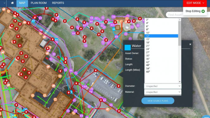
NOVATO, Calif. - Sept. 29, 2021 - PRLog -- We're excited to announce the latest release of Uvara. This release focuses on providing the ability to edit attributes of any of their thousands of assets (pipes, cables, valves, etc.) and manage the commits to the core database. Municipal water/wastewater, electrical cooperatives, healthcare, commercial real estate are examples of industries that will benefit.
Users gain an easy-to-use desktop and mobile experience for work crews and managers to update missing or incorrect information about assets attributes. Users can edit, update, and roll back data in the field or back in the office. Managers can review edit logs to approve and keep the changes done to the master database, or to roll back if they see that edits were done erroneously. Existing users logging into the various browsers will notice they already have access to the new editing and administrative functions.
"For many facility managers, incomplete or incorrect data in water, electric, or telecom networks is a big issue," says Moufid Charafeddine, CTO, BetterGIS. "It takes time and planning effort to collect and prepare changes in batches and perform the data uploads. We are giving the users another way to incrementally update the information of an unlimited variety of structures and utility networks."
Uvara is designed for facility managers to subscribe and have up-to-date information, analysis, and planning for their existing infrastructure built from scratch in a few weeks and stay updated. Assets information are digitized by the Uvara professional services team, integrated from paper maps or CAD/GIS drawings with tabular attributes such as size, year, maintenance schedule, etc.
"We designed editing to fit smoothly into the normal workflow of engineers and technicians," adds Moufid. "With a simple search in tens of thousands of network elements or point-and-click on a map, users can immediately update information as it is discovered to be instantly accessible to all authorized internal and external parties. Managers can make changes in a simple dashboard interface at their own pace."
Data accuracy is enhanced by obtaining drone high-resolution images and performing field-verification walks. Once the data is integrated, IoT and AR information can be tied together for a spatial digital twin. This live and current twin of infrastructure is used by facility managers for scheduling maintenance, responding to emergencies, preparing budget and capital plans as well as guiding new opportunities for construction.
About BetterGIS
BetterGIS is a San Francisco area startup company. Uvara addresses the full lifecycle of the assets starting with the engineering, planning, and construction phase and continues through operation and maintenance and financial planning. For more information, visit www.Uvara.com.
Contact
Linda Stevens
***@uvara.com
Photos: (Click photo to enlarge)


Read Full Story - Uvara Solution Now Includes Powerful Editing and Data Management Capabilities | More news from this source
Press release distribution by PRLog
Uvara Solution Now Includes Powerful Editing and Data Management Capabilities
September 29, 2021 at 16:58 PM EDT


